
There’s no shortage of baous on the French Riviera. But if you’re not from Nice or the French Riviera, you’re probably wondering what a baou is…. That was my reaction ten years ago when I arrived straight from the Paris suburbs and found myself confronted with a new vocabulary that I’d never heard before from either Adam or Eve. I was trained on the job by a group of people who were passionate about nature and who took me to explore the famous baous on the French Riviera. These hikes have become part of my routine over the last few years, and you’ll understand why.
What is a baou?
According to Wikipedia, a baou is a hill or cliff with a flat top. There are several in the Alpes Maritimes, but also in the south-west in the Hautes-Pyrénées and Languedoc regions.
In the Alpes Maritimes, there are 6 of them, but I’m mainly going to tell you about four baous (the best known). Four marvellous walks with breathtaking views to discover without hesitation.
Hiking in the baou of St Jeannet
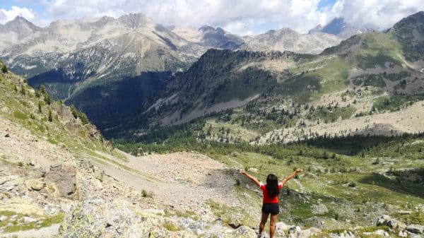
The Baou de Saint-Jeannet is the best-known of all the baous in the Alpes Maritimes. At an altitude of 782m, the baou can be seen from a large part of Nice’s coastline (even from the airport) and has become a feature of the Côte d’Azur. As well as being a great place to hike, the baou de saint-jeannet is also a popular spot for rock-climbing enthusiasts. The ascent is gradual, despite a few passages that climb all at once, but that’s nothing compared to the Path du Paradis, with its 520 metre difference in altitude from Bar sur Loup to the village of Gourdon, where I thought I was going to die from the steepness of the slope!
At the top, you’ll discover a completely different face of the Côte d’Azur (as with all the baous, by the way): a 360° panoramic view from Italy to the Var that you can immortalise with your smartphones.
Practical info
- The departure point is at the car park in the village of St Jeannet (8km from Vence). The starting point is already more than 400m above sea level
- Altitude: 782m
- Difficulty: medium (according to visorando)
- Difference in altitude: 403 metres
- Average duration: 2h50 (for normal walkers, including breaks)
- Recommended period: spring to autumn (but avoid summer)
- Tip: bring good hiking boots, a pair of glasses, a bottle of water and a picnic while admiring the view


Hike to Baou des Blancs
Without doubt my favourite walk of all! Of course, this hike to the Baou des Blancs offers incredible views of the Alpes Maritimes, like all the Baous, but it was the views of the Col de Vence and the village of Vence that particularly impressed me. The ascent is also gradual and the starting point is at a “Poneys Vençois” riding school (so you can see some very fine horses)
Practical info
There are several starting points, but I usually begin the walk either at Villa Casamaste, where I park my car, and then cross a steep 1km path to get to the riding centre. Alternatively, you can park your car in the few spaces available on the Route de Coursegoules at the bottom of the centre, but it’s a matter of luck! The starting point is already more than 500m above sea level.
- Altitude: 673m
- Difficulty: moderate (according to visorando) but easy for me
- Difference in altitude: 300 metres
- Average duration: 3 hours (for normal walkers, including breaks)
- Recommended period: spring to autumn (but avoid summer)
- Tip: bring good hiking boots, a pair of glasses, a bottle of water and a picnic while admiring the view


Hike to Baou des Noirs
The baou des noirs hike has the same starting point as the baou des blancs (route de coursegoules, equestrian centre, gradual ascent, view of the Col de Vence…). The paths separate at a bend: if you go straight on, you’ll head for the baou des blancs; if you take the bend, you’ll head for the baou des noirs.
There are some absolutely sublime views on this walk too, including a striking view of the baou de st Jeannet. At the top, you’ll see a metal cross marking the summit of the baou. Nearby, you can see the ruins of walls that once belonged to a fortified camp built by the Romans.
Practical info
- Altitude: 673m
- Difficulty: moderate
- Difference in altitude: 260 metres
- Average duration: 2h to 2h30 (for normal walkers, including breaks)
- Recommended period: spring to autumn (but avoid summer)
- Tip: bring good hiking boots, a pair of glasses, a bottle of water and a picnic while admiring the view


Hiking in the baou of La Gaude
The baou de la Gaude is actually in St-Jeannet and not in la Gaude… It also offers a magnificent view over the Alpes Maritimes and the Var plain in particular. During this walk, you’ll come across a large oak tree, over 400 years old and 7 metres tall! It’s the main attraction of this walk. Compared with the other baous, it is less popular due to its slightly more difficult accessibility (its gradient is the highest of the other baous).
You can start the hike from either St Jeannet or Gattière. The altitude is already 400m.
Practical info
- Altitude: 796m
- Difficulty: difficult
- Difference in altitude: 580 metres
- Average duration: 3h30
- Recommended period: spring to autumn (avoid summer as there is no shade)
- Tip: bring good hiking boots, a pair of glasses, a bottle of water and a picnic while admiring the view


