There are many walks and hikes on the French Riviera that offer an incredible view of the sea. Today, I present you a new hike that I discovered near Grasse and which apparently bears the very poetic name of the path of Paradise “Chemin de Paradis”. In reality, I rather want to say that it is the Way of Calvary 😅 because we still suffered a lot! Expect an hour of progressive and intense climbing at the same time. Forget the flat, you won’t find any.
This path will lead you to the village of Gourdon, one of the most beautiful villages of the French Riviera and France perched at 800 meters above sea level on a rocky spur.


1. Its history
Every hike has its own story, the path of paradise is no exception to the rule. Inevitably, we’ve all asked ourselves “but why is Paradise Road called Paradise Road?”
According to legend, the village of Bar sur Loup had no cemetery and when one of its inhabitants died, he had to be taken to the nearest cemetery which was in the village of Gourdon. Perched at an altitude of 800m, the coffin had to be carried on the back of a very steep and stony path with a high difference in altitude of more than 500m. A path that winds in the middle of a vertical relief with imposing and impressive cliffs of 700 meters high.
To take this path was symbolic because one had the impression to transport the deceased close to the sky and thus “in the paradise”.
Interesting no?!


2. The different routes
Either you start from the top of the village of Gourdon, or you start from the bottom of Bar sur Loup.
- If you start from the bottom, you will have to park near the cemetery of Bar sur Loup and take the path on the right of the road.
- If you start from the top, you will have to park at the parking lot of the village of Gourdon and join the Basse street. At the end of this street, you will find a small square with a great view. Straight ahead, there will be a small passage to start the way to paradise.
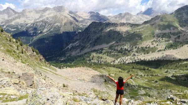
And as usual, the view is always so grandiose and spectacular once you reach the top. Sensations guaranteed!

3. Some practical information
- Difficulty: medium
- Difference in altitude: 520m
- Duration : 3h round trip
- Kilometers : 6km
- If you start from the bottom of Bar sur Loup, you will be hidden for a good part under big trees. Indeed, this first part is shaded. The more you go up, the more the view will be discovered.
4. Equipment to bring
- A good pair of hiking boots because the path is very stony. Be careful on the way down!
- A bottle of water. You will need it especially for the one hour climb.
- Hiking poles would be a good addition.
- Cap and sunglasses if the day is sunny


