
The PACA region is widely appreciated for the beauty of its landscapes between the horizon of the sea and the relief of the hills in the hinterland. And it is particularly the hiking spots on theFrench Riviera that are in vogue. In addition to its aesthetic side, the strength of this beautiful region is that it offers a variety of walks of all kinds, from seaside walks on the French Riviera to hikes in the Mercantour, which rise up to 2,500 metres above sea level, and in between, we have walks that could be called “middle country”, which are fairly accessible and some of which offer majestic views, whether of the sea or the emerald green river, such as the Pont des Tuves. These are perfect alternatives when we don’t have time for long walks.
Here is a non-exhaustive list of hikes on the French Riviera that are a must to enjoy the beautiful views of the region.
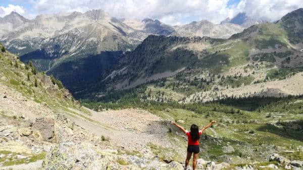
1. Baou des blancs
This is a superb walk to do, especially in spring. Indeed, the landscape takes back colour, the Mediterranean plants are reborn from their ashes and it’s time for the picking season! This walk is considered moderate and is easily accessible for running and walking. Once you reach the top, you can admire the panoramic view of the sea, the town of Vence and the Col de Vence. The end of the day is the best time to go for this walk to enjoy the beautiful lights at sunset over a small picnic.
- Departure: you can leave from the tourist office in Vence but there is a small car park for this walk. To do so, you have to take the chemin du Riou to get there. For my part, I park either on the chemin de la salle or the chemin de la source which is on the other side.
- Altitude: 673 metres
- Distance: 1.6km
- Time: it takes 2 hours round trip and 50 minutes to reach the summit


Walk to Baou des Blancs
2. Baou des noirs
The starting point of this superb walk is the same as the Baou des Blancs. The difference is that there is a fork in the road: if you go straight on, it’s directly to the baou des blancs, if you turn left, you go to the baou des noirs. The distance to the top of the baou des noirs is longer but it is worth it. Its viewpoint is sublime and offers us a panoramic view of the baou of Saint Jeannet and of La Gaude.
Once arrived at the top, we find this famous wrought iron cross around which we can rest while picnicking in front of the incredible view.
Be careful, for this walk, you must bring hiking shoes because the path becomes very stony and steep at the same time. Also, bring a cap and sunglasses on a sunny day as the walk is completely open.
- Departure : Cf. Baou des blancs
- Altitude : 673 meters
- Distance : 4,2km
- Time : 3h30


Walk to Baou des Noirs
3. Baou of Saint-Jeannet
This is the most famous baou on the Côte d’Azur as it is visible from the coast (motorway, airport, residence…). The walk is relatively easy despite some steep slopes but nothing serious. Hiking shoes are welcome. When you reach the top, you are amazed by the 360° panoramic view of the Mercantour and the Var.
- Departure : park in the village of Saint-Jeannet
- Altitude: 802 metres
- Distance : 5,94km
- Time : 3 hours


Walk in the Baou of Saint-Jeannet
4. The Cap Roux in the Esterel
Direction the Var between Agay and Théoule sur Mer and more precisely the red rocks of the Estérel massif which is also called the small canyon of the south (in reference to the big canyon). There are several hikes but the most famous is the one from Cap Roux. Its 360° view is just incredible! Its distance from the sea is only 1km and you can see the famous calanque of Saint-Barthélémy.
- Departure point: car park of the Sainte-Baume
- Altitude: 454 metres
- Distance: 4.3km
- Time: 2 hours


Walk on the Pic du Cap Roux
5. Fort de la Revère
This is the most accessible high altitude walk in Nice and it is practical if you don’t feel like driving. The Fort de la Revère, which is a former military structure built in 1882 above the village of Eze, is located in the forest park of the Grande Corniche. Considered a moderate walk, the loop can be done as a stroll, a run or even a mountain bike ride. Its panoramic view is breathtaking and goes from the Esterel to Italy.
- Departure point : Fort de la Revère car park
- Altitude: 696 metres
- Distance : 7km
- Time : 2h30


Walk to the Fort de la Revère
6. Mont Chauve
Like the baou of Saint-Jeannet, the bald mountain is visible from the coast. There are in fact two bald mountains, that of Aspremont and that of Tourrette. Both give a remarkable view of the city of Nice and the surrounding area on the south side. At the top there is a fort which gives a superb view of the Mercantour mountains on the north side. We can do it by trail, by bike or by walk.
- Departure : Aire de St Michel or car park in the village of Aspremont
- Altitude : 700 meters
- Distance : 7,48km
- Time : 3 hours


Walk to Mont Chauve
7. The Pic des Courmettes
This superb hike is not far from the village of Tourrettes sur Loup. In the form of a loop, this walk offers us views from all horizons. First of all, we are amazed by the panoramic view of the sea which goes from Italy to the Var. As you continue along the route, you come face to face with one of the most beautiful perched villages in the south, Gourdon. Seen from the Pic des Courmettes, its position is even more impressive as it is a village perched in an eagle’s nest on a 760 metre high cliff.
- Departure : Domaine des Courmettes
- Altitude: 1229 metres
- Distance: 5.65km
- Time : 2h45


Walk to the Pic des Courmettes
8. Tour of the Roc de l’Orméa
Without doubt, the most difficult hike on the Côte d’Azur that I have done among those listed in this article. This hike, close to the coast, overlooks the town of Menton. It is known to be difficult and sportive. I clearly “shat”, excuse the term. The funny thing about this hike is that once you reach the top, you are on the French-Italian border. My friends preferred to have lunch with a view of France, I opted for Italy.
- Departure : Village of Castellar
- Altitude : 1124 meters
- Distance : 10km
- Time : 5 hours


Walk to the Roc de L’Orméa
9. The Cap Dramont
A superb hike accessible to all, with breathtaking landscapes, notably on the Estérel massif, the bay of Agay and Saint-Raphaël. In addition, there is a semaphore at the top of the cape overlooking the Mediterranean Sea. It is used by the national navy, its position is indeed very strategic for a military, maritime and air surveillance. Another special feature is the unobstructed view of the Golden Island and its tower built in 1912.
- Departure point: Camp Long Beach car park
- Altitude: 125 metres
- Distance: 4.54km
- Time: 1 hour 45 minutes


Cap Dramont
10. The Pyramid of Falicon
A simple but effective hike with the Falicon pyramid as a pretext, otherwise known as the ratapignata cave (bat in Niçois). The pyramid itself is not extraordinary, on the contrary, it is in a pitiful state. On the other hand, it is a good reason to make this walk just for the panoramic view which is breathtaking! To be done on a good spring day or in autumn. To be avoided in summer because of the high temperatures.
- Start : Aire Saint-Michel
- Altitude: 557 metres
- Distance : 5,12km
- Time : 2 hours


The Pyramid of Falicon
And you, which hiking spot on the French Riviera do you prefer?


